

Geofencing Explained for Fleet Managers: How Virtual Boundaries Improve Fleet Operations

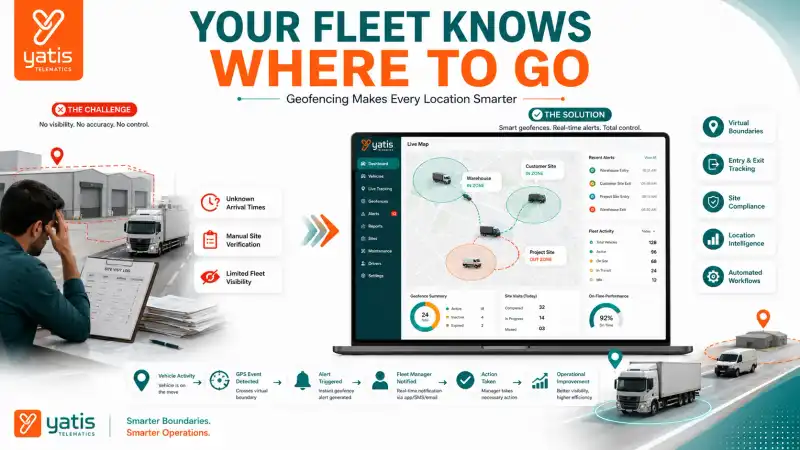
Managing a fleet isn't just about knowing where vehicles are — it's also about understanding when they arrive, where they operate, and whether they stay within approved locations. This is where geofencing becomes valuable.
By creating virtual boundaries around locations such as warehouses, customer sites, depots, construction projects, or service areas, fleet managers gain greater visibility into vehicle movement without relying on manual updates. Modern GPS tracking systems use geofencing to automatically detect when vehicles enter or leave designated areas, helping businesses improve operational control, strengthen asset security, and simplify location-based reporting.
Quick Takeaways
- Create virtual boundaries around important locations
- Monitor vehicle entry and exit
- Improve operational visibility
- Strengthen asset security
- Automate location-based workflows
- Support compliance and reporting
- Enhance fleet efficiency
At a Glance
| Business Challenge | How Geofencing Helps |
|---|---|
| Limited visibility at job sites | Detects vehicle entry and exit |
| Unauthorized vehicle movement | Monitors movement beyond approved areas |
| Manual attendance verification | Records arrival and departure automatically |
| Difficulty tracking site visits | Creates digital location history |
| Asset security concerns | Improves location awareness |
| Limited operational visibility | Provides real-time location intelligence |
What Is Geofencing?
Geofencing is a location-based technology that creates virtual boundaries around real-world locations using GPS coordinates. When a vehicle crosses one of these virtual boundaries, the fleet management system records the event and can perform predefined actions based on that movement.
Unlike physical fences, geofences exist digitally. Fleet managers define geographic areas on a digital map, and the system continuously compares vehicle location with those boundaries. When a vehicle enters the area, leaves the area, or remains inside the area, the platform records the activity and makes it available for operational reporting. Geofencing transforms simple GPS location data into actionable business intelligence.
How Does Geofencing Work?
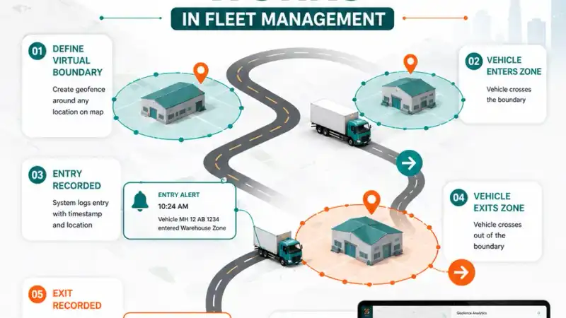
Geofencing combines GPS location data with digital map coordinates. The process generally follows four simple steps:
- Define a virtual boundary around a location
- Continuously monitor vehicle GPS positions
- Compare vehicle location with the virtual boundary
- Record entry or exit events when the boundary is crossed
This process happens automatically in the background and requires no manual intervention once the geofence has been configured. Because the technology relies on accurate vehicle positioning, geofencing works best when integrated with a reliable GPS tracking system that provides continuous location updates. For the underlying mechanics, see How Does a GPS Tracking System Work?
1. Monitor Vehicle Entry and Exit Automatically
One of the most common applications of geofencing is monitoring when vehicles arrive at or leave important locations. Instead of depending on drivers to report arrival times, fleet managers receive objective location records that show exactly when vehicles crossed a predefined boundary. Typical monitored locations include:
- Distribution centers
- Warehouses
- Customer facilities
- Construction sites
- Service locations
- Corporate offices
- Parking yards
Automatic entry and exit records improve operational transparency while reducing manual reporting.
2. Improve Operational Visibility Across Multiple Sites
Organizations with numerous operating locations often struggle to maintain consistent oversight. Geofencing provides a centralized view of vehicle movement across all approved sites. Fleet managers can quickly understand which vehicles have arrived, which vehicles have departed, how long assets remained on site, and whether scheduled visits occurred. This improved visibility supports better planning and more informed operational decisions.
3. Strengthen Asset Security with Location Awareness
Geofencing also plays an important role in protecting valuable fleet assets. By defining approved operating areas, businesses gain greater awareness of vehicle movement and can identify situations where assets move outside expected locations. Examples include:
- Vehicles leaving a depot after business hours
- Equipment moving beyond an authorized work zone
- Assets relocated without prior approval
- Vehicles entering restricted operational areas
Rather than relying solely on periodic location checks, geofencing creates a structured framework for monitoring asset movement based on predefined business locations.
4. Improve Site Compliance with Geofencing
Geofencing helps businesses improve site compliance by automatically recording when vehicles enter and exit approved work locations. This creates accurate location records that support operational transparency and simplify compliance reporting.
Many industries require vehicles to operate only within designated work zones. Without automated monitoring, verifying site visits often depends on manual logs or driver updates, which can be inconsistent and time-consuming. Geofencing provides objective location records by documenting arrival time, departure time, duration at the site, frequency of site visits, and vehicle movement between locations.
Industries that particularly benefit include construction, utilities, mining, municipal services, and field service operations.
5. Verify Customer Visits More Accurately
Geofencing automatically verifies customer site visits by recording vehicle arrival and departure at predefined locations, improving service transparency and reducing manual reporting.
Service-based businesses often need to confirm whether scheduled visits actually occurred. Instead of relying on handwritten logs or verbal confirmations, geofencing provides timestamped digital records. Fleet managers can verify customer arrival, departure time, time spent on-site, number of completed visits, and route progression throughout the day.
6. Support Workforce Attendance and Field Operations
Geofencing simplifies workforce attendance by automatically recording when employees or company vehicles arrive at and leave designated work locations, reducing manual attendance tracking. Common applications include:
- Technician arrival verification
- Field engineer attendance
- Service team deployment
- Project site reporting
- Utility workforce tracking
Rather than replacing HR attendance systems, geofencing provides operational evidence that supports workforce management and scheduling.
7. Improve Asset Security with Approved Operating Zones
Geofencing improves asset security by defining approved operating areas and identifying when vehicles move outside those designated locations. Commercial vehicles and heavy equipment represent significant business investments. By establishing approved operating zones, fleet managers gain better awareness of where assets are expected to operate:
- Construction equipment assigned to a project
- Mining vehicles restricted to operational areas
- Rental equipment allocated to customer sites
- Delivery vehicles assigned to regional service zones
Location intelligence helps businesses investigate unexpected movement while maintaining better oversight of fleet assets.
8. Automate Business Workflows Using Location Data
One of geofencing's greatest advantages is its ability to automate routine operational processes. Instead of requiring employees to manually update job status, location events can become workflow triggers — recording vehicle arrival, logging departure time, updating delivery status, marking service completion, creating operational reports, and supporting dispatch decisions.
Automation reduces manual administration while improving the consistency of operational records. Businesses using fleet management software can combine geofencing with centralized dashboards to streamline location-based workflows across multiple operating sites.
Industry Applications of Geofencing
Although geofencing relies on a simple concept, its applications vary across industries.
Logistics & Distribution
Warehouse arrival verification, distribution center tracking, and cross-docking visibility.
Construction
Equipment location monitoring, site compliance, and project attendance verification.
Mining
Approved work zone monitoring, equipment movement visibility, and restricted area management.
Field Service
Customer visit verification, technician arrival records, and service completion tracking.
Public Transportation
Depot entry and exit records, terminal operations, and fleet scheduling support.
Utilities
Crew deployment monitoring, infrastructure site visits, and service area management.
Because geofencing is location-driven rather than industry-specific, it adapts well to organizations operating vehicles across multiple sites and regions.
Make Better Decisions with Geofencing Analytics
Geofencing helps fleet managers make better operational decisions by converting vehicle entry, exit, and location history into actionable insights that improve planning, accountability, and resource utilization. Creating virtual boundaries is only the first step — the real value comes from analyzing how vehicles interact with those locations over time.
A modern geofencing solution enables fleet managers to answer questions such as:
- Which sites receive the highest number of vehicle visits?
- Which locations experience frequent delays?
- Which vehicles spend excessive time at customer sites?
- Which work zones are underutilized?
- Which operational locations require additional resources?
These insights help organizations optimize processes using objective location intelligence rather than manual observations.
Business Challenges vs Geofencing Solutions
| Business Challenge | Geofencing Solution |
|---|---|
| Manual arrival reporting | Automatic entry records |
| Limited site visibility | Virtual boundaries |
| Customer visit verification | Timestamped location history |
| Asset movement uncertainty | Approved operating zones |
| Workforce attendance tracking | Automated arrival and departure logs |
| Manual workflow updates | Location-based automation |
| Multi-site fleet operations | Centralized geofence monitoring |
Common Mistakes Fleet Managers Make When Using Geofencing
Geofencing delivers the best results when virtual boundaries are aligned with operational goals. Avoid these common mistakes:
1. Creating Geofences That Are Too Large
Large virtual boundaries reduce accuracy and operational usefulness. Oversized geofences may record inaccurate arrivals, trigger premature departures, and reduce reporting precision. Instead, create boundaries that closely match the physical operating area while accounting for GPS accuracy.
2. Geofencing Every Location
Not every location requires a virtual boundary. Focus on locations that have operational significance, such as warehouses, distribution centers, customer facilities, construction projects, service hubs, and company depots. A focused geofencing strategy keeps reports meaningful and easier to manage.
3. Ignoring Historical Location Data
Many businesses only view live vehicle locations. Historical geofence records provide valuable insights into site visit frequency, time spent at locations, operational consistency, resource utilization, and service performance. Reviewing historical trends helps improve planning and operational efficiency.
4. Treating Geofencing Only as a Security Tool
Although geofencing strengthens asset security, its value extends much further. Businesses also use geofencing for operational planning, customer service, attendance verification, workflow automation, fleet reporting, and compliance monitoring.
5. Failing to Review Geofence Performance
Business operations evolve over time. New customer locations, project sites, and service areas require regular updates to geofence configurations. Periodically reviewing virtual boundaries helps ensure they remain aligned with current operational requirements.
Geofencing KPIs Every Fleet Manager Should Track
| KPI | Why It Matters |
|---|---|
| Site Visit Completion Rate | Measures operational consistency |
| Average Time on Site | Identifies productivity trends |
| Entry Accuracy | Confirms arrival reliability |
| Exit Accuracy | Improves reporting quality |
| Unauthorized Movement Events | Supports asset visibility |
| Location Compliance Rate | Measures adherence to approved sites |
| Customer Visit Verification | Improves service accountability |
| Vehicle Utilization by Location | Supports resource planning |
| Geofence Event History | Provides operational insights |
Tracking these KPIs helps organizations evaluate how effectively vehicles interact with operational locations and identify opportunities for process improvement.
Geofencing Best Practices Checklist
Review your current operations against this checklist:
- Virtual boundaries are created for critical business locations
- Site entry and exit records are reviewed regularly
- Customer visits are verified using geofence history
- Approved operating zones are clearly defined
- Historical location data is analyzed
- Operational reports include geofence activity
- Geofences are updated as business locations change
- Location intelligence supports planning decisions
If several of these practices are missing, your organization may not be realizing the full operational value of geofencing.
Final Thoughts
Geofencing transforms GPS location data into actionable business intelligence. Instead of relying on manual updates or assumptions, fleet managers gain accurate, location-based visibility into vehicle activity across depots, customer sites, project locations, and service areas.
From improving compliance and verifying customer visits to supporting asset security and automating operational workflows, geofencing helps businesses make better decisions based on reliable location data. When implemented as part of a modern GPS tracking system, geofencing becomes a powerful tool for increasing operational transparency, improving efficiency, and strengthening overall fleet management.
At Yatis, our GPS tracking system and fleet management platform enable businesses to create intelligent geofences, monitor vehicle movement in real time, and gain deeper operational insights through location-based analytics.
Frequently Asked Questions
Ready to get started?
Contact Yatis Telematics to learn how intelligent geofencing can improve visibility and automate location-based workflows across your fleet.
Contact Us →