

GPS Tracking for Ambulances & Emergency Vehicles: How It Improves Response Time

In ordinary fleet operations, a vehicle arriving a few minutes late can be an inconvenience. For an ambulance responding to a medical emergency, the stakes are very different.
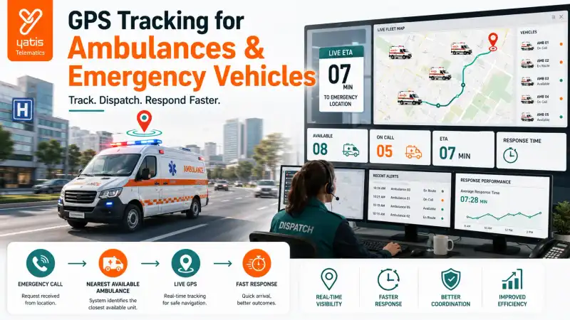
The operational question isn't simply where the ambulance is. It is which available ambulance can reach the emergency fastest. That requires more than a list of vehicles. Dispatch teams need visibility into current ambulance locations, vehicle availability, active assignments, traffic and route conditions, estimated arrival, response history and overall fleet availability.
This is where emergency fleet GPS becomes a critical operational layer. The Ministry of Health & Family Welfare's 2026 National Ambulance Services guidelines explicitly recommend Integrated Command and Dispatch Centres supported by GPS-enabled ambulance tracking, digital call management, intelligent dispatch, and real-time monitoring.
Quick Takeaways
- Real-time visibility of every ambulance in the fleet
- Vehicle status alongside vehicle location
- Faster, better-informed dispatch decisions
- Live ETA for crews and receiving facilities
- Measurable response-time KPIs
- Demand-based ambulance positioning
- Fleet readiness through maintenance visibility
What Is Emergency Fleet GPS?
Emergency fleet GPS is a vehicle-tracking system used to monitor ambulances and other emergency vehicles in real time. It provides dispatch teams with vehicle location and status information that can support faster ambulance allocation, route decisions and response-time monitoring.
A simplified architecture runs: Emergency Call → Command and Dispatch Centre → Fleet GPS Platform → Available Ambulances → Dispatch → Live Journey Monitoring.
The GPS component provides the location intelligence. The dispatch system uses that information to make operational decisions. This distinction matters: GPS tracking alone does not dispatch an ambulance. It provides the location data that a dispatch workflow can use.
Why Response Time Matters in Emergency Fleets
Ambulance response time is the time taken for an emergency service to respond to a request and reach the incident location. GPS tracking can help measure and improve this process by providing real-time fleet visibility and historical response data.
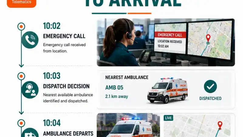
A typical emergency journey involves multiple timestamps: emergency call, dispatch decision, ambulance departure, arrival at scene, patient transport and hospital arrival. Each stage can potentially be measured.
GPS tracking is particularly useful because vehicle movement can be monitored continuously rather than relying entirely on manually recorded updates. Research on emergency medical services has identified ambulance response time as an important indicator of EMS performance.
How GPS Helps Dispatchers Find the Right Ambulance
GPS tracking helps dispatchers identify nearby available ambulances by displaying their real-time locations and operational status. When integrated with dispatch software, this information can support selection of an appropriate ambulance based on location, availability and route conditions.
Imagine a control room receives an emergency call with four ambulances nearby:
| Ambulance | Location | Status |
|---|---|---|
| A01 | 4 km away | Available |
| A02 | 2 km away | Returning to hospital |
| A03 | 5 km away | On another call |
| A04 | 3 km away | Available |
The closest vehicle geographically isn't necessarily the best vehicle to dispatch. The dispatcher also needs to consider availability, current assignment, route, traffic, vehicle suitability, destination and operational status.
This is why emergency fleet management needs location, status and dispatch intelligence together. The 2026 NAS guidelines specifically recommend intelligent dispatch supported by GPS tracking and GIS-based mapping.
Real-Time Ambulance Visibility
A centralized command centre can display the emergency fleet on a single operational map, with each vehicle colour-coded by state: available, on emergency call, returning, at hospital or under maintenance.
This gives dispatchers a much clearer understanding of the fleet's current state. Instead of asking which ambulance is free, the control room can identify available vehicles directly from the platform.
The Ministry of Health's paramedic training material describes centralized ambulance control rooms using GIS and GPS-equipped ambulances and systems that can recommend the nearest available ambulance for dispatch.
GPS Plus Dispatch: The Real Operational Advantage
GPS tracking becomes more valuable for emergency fleets when integrated with dispatch software. GPS provides vehicle location, while dispatch systems combine location with availability, emergency requests, routing and operational rules to support deployment decisions.
GPS Tracking
Answers: where is the ambulance?
Dispatch System
Answers: which ambulance should respond?
Fleet Management
Answers: how effectively is the entire emergency fleet operating? Understanding the difference between GPS tracking and fleet management software is useful when scoping a solution.
Together, GPS, dispatch and fleet management create a more complete emergency-response workflow.
Monitor Ambulance Response Time
Response-time monitoring is one of the strongest operational applications. A system can potentially capture call received time, dispatch time, departure time, arrival-at-scene time, hospital arrival time and trip completion. This creates measurable KPIs.
For example: call received at 10:02, dispatch at 10:03, ambulance departed at 10:04, arrived at scene at 10:12. The operator can then analyse call-to-dispatch time, dispatch-to-arrival time and total response time.
This is far more useful than simply knowing that an ambulance completed a trip.
Identify Response-Time Bottlenecks
GPS-based response-time analysis can help emergency fleet operators identify where delays occur, such as dispatch delays, vehicle availability problems, traffic-heavy routes, poor ambulance positioning, or prolonged turnaround times.
Suppose a fleet's average response time increases. GPS and operational data can help investigate whether the problem comes from:
Dispatch
Was the ambulance assigned too slowly?
Positioning
Were too few vehicles available in the affected area?
Traffic
Did road conditions increase travel time? Route optimization can help address recurring route-level delays.
Availability
Were nearby ambulances already engaged?
Turnaround
Were ambulances spending too long at hospitals before becoming available?
The objective is to move from "response time is getting worse" to "we know where the delay is occurring."
Ambulance Positioning Based on Demand
This is one of the most important applications of GPS for emergency fleets. A fleet doesn't necessarily need to position ambulances based only on fixed stations.
Historical data can reveal emergency call concentrations, accident hotspots, high-demand zones, time-of-day patterns, geographic gaps and seasonal demand.
The 2026 NAS guidelines specifically recommend evidence-based ambulance deployment using factors including emergency call trends, accident hotspots, traffic density, geographical constraints and population distribution.
This creates a powerful operational loop: historical data reveals demand patterns, demand patterns drive fleet positioning, better positioning produces faster availability, response-time monitoring measures the result, and that measurement becomes new data. The fleet becomes progressively more data-driven.
GPS Tracking for Emergency Vehicles Beyond Ambulances
The same principle can apply to other emergency fleets. Depending on the operation, this can include fire-response vehicles, rescue vehicles, disaster-response vehicles, medical response vehicles, utility emergency vehicles and specialized emergency support vehicles.
The common requirement is the same: know where the response asset is and whether it can be deployed. The technology therefore isn't limited to ambulance operators.
Live ETA for Emergency Vehicles
Live GPS tracking can provide estimated arrival information by combining a vehicle's current position with route and traffic information. For emergency fleets, this can help dispatchers and receiving facilities understand the vehicle's expected arrival.
The ETA can be updated as vehicle location changes, traffic conditions change and route conditions change. This creates better operational coordination between the dispatcher, the ambulance crew and the receiving facility.
Some emergency fleet platforms explicitly combine live GPS, dispatch and ETA functionality to provide continuous journey visibility.
Historical Fleet Data Improves Emergency Operations
Real-time tracking is only one side of the equation. Historical GPS data can answer which areas generate the most calls, which stations have the highest demand, which routes produce longer response times, when fleet availability is lowest, which vehicles spend excessive time unavailable, and where additional resources should be positioned.
This turns GPS data into a planning tool. Instead of using GPS only during emergencies, operators can use historical information to improve the system between emergencies.
Ambulance Fleet Availability
An emergency fleet cannot respond effectively if too many vehicles are unavailable. A centralized platform can help categorize vehicles by status: available, dispatched, at scene, transporting patient, at hospital, returning, or under maintenance.
This allows dispatchers to see not merely the fleet's location, but its operational availability. That distinction is crucial. A vehicle 2 km away but already carrying a patient isn't an available response vehicle.
Fleet Maintenance and Emergency Readiness
Emergency vehicles need to be available when an emergency occurs. Fleet management can help monitor maintenance schedules, vehicle downtime, service intervals, vehicle availability and operational status.
The goal is not simply to maintain vehicles properly. It is to know which vehicles are actually available for emergency deployment. This creates a direct connection between fleet management and emergency readiness.
What Should Emergency Fleet Operators Look For?
A suitable emergency fleet GPS solution should be evaluated on more than basic location tracking.
1. Real-Time Tracking
Can the control room see the entire fleet?
2. Vehicle Status
Can dispatchers distinguish available and unavailable vehicles?
3. Dispatch Integration
Can GPS data support dispatch decisions?
4. Live ETA
Can the system provide useful arrival estimates?
5. Response-Time Analytics
Can operators measure response performance?
6. Historical Data
Can operators analyse previous emergency journeys?
7. Fleet Availability
Can maintenance and operational status be incorporated?
8. Scalability
Can the platform support multiple stations and geographic areas?
9. Emergency Compliance
Where applicable, does the hardware and platform support the required vehicle-tracking and emergency-alert standards? For India, the NAS 2026 guidelines state that ambulances should comply with AIS-125 standards and promote GPS-enabled tracking and integrated command-and-dispatch infrastructure.
Emergency Fleet GPS vs Basic Vehicle Tracking
| Basic GPS Tracking | Emergency Fleet Management |
|---|---|
| Vehicle location | Vehicle location plus availability |
| Map visibility | Command-centre visibility |
| Trip history | Response-time analytics |
| Basic alerts | Dispatch-oriented alerts |
| Vehicle monitoring | Emergency resource coordination |
| Historical journeys | Response-performance analysis |
| Individual vehicle view | Fleet-wide operational view |
The difference is therefore not simply more features. It is a different operational objective. Basic GPS asks where the vehicle is. Emergency fleet management asks which vehicle can respond, how quickly it can reach the scene, and how the fleet is performing.
Key Benefits of Emergency Fleet GPS
| Capability | Operational Benefit |
|---|---|
| Real-time ambulance location | Better dispatch visibility |
| Fleet availability | Identify deployable vehicles |
| Intelligent dispatch support | Select suitable units |
| Live ETA | Improve coordination |
| Response-time measurement | Track performance |
| Historical analysis | Identify recurring delays |
| Demand mapping | Improve ambulance positioning |
| Fleet monitoring | Improve operational control |
| Maintenance visibility | Improve fleet readiness |
The Emergency Response Data Loop
The strongest emergency fleet systems create a continuous data loop: an emergency call arrives, dispatch begins, GPS informs vehicle selection, the ambulance travels under live monitoring, it arrives at the scene, the patient is transported to hospital, the trip completes, response data is stored, fleet performance is analysed, and future deployment improves as a result.
This is the real value of GPS in emergency operations. It doesn't merely track the ambulance. It creates data that can improve how the emergency fleet is deployed.
The Business Case for Emergency Fleet GPS
The value proposition is straightforward: better visibility leads to better dispatch decisions, which leads to better fleet utilization, which leads to better response-time management, which leads to more data-driven emergency operations.
The 2026 national ambulance guidelines' emphasis on GPS tracking, intelligent dispatch, GIS mapping and data-driven deployment strongly reinforces this direction for India's ambulance ecosystem.
Final Thoughts
For an emergency fleet, location is operational intelligence. Knowing where ambulances are allows dispatch teams to understand what resources are available. Knowing which vehicles are available allows better dispatch decisions. Recording the journey allows response times to be measured. Analysing historical response data allows fleet positioning and resource allocation to improve over time.
That creates a continuous operational cycle: track, dispatch, respond, measure, improve.
For ambulance operators, hospitals, emergency-service providers and other response organizations, an emergency fleet GPS solution can therefore become much more than a vehicle-location system. Integrated with a broader fleet management solution, it can provide the visibility required to coordinate emergency vehicles, monitor response performance and make better resource-allocation decisions.
And in emergency operations, improving the decision made before the vehicle moves can be just as important as optimizing the journey after it leaves.
Frequently Asked Questions
Ready to get started?
Contact Yatis Telematics to learn how emergency fleet GPS can help your dispatch team reach every incident faster.
Contact Us →