

Fleet Visibility Beyond GPS: Why Modern Fleets Need More Than Location Data

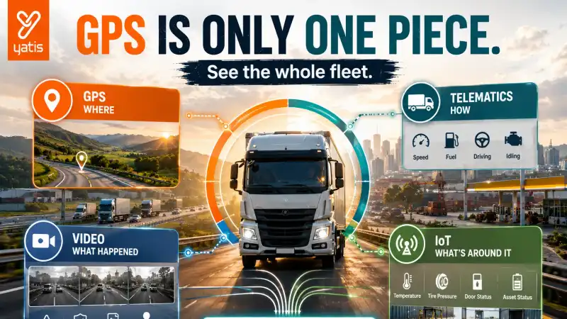
GPS answered one of fleet management's most important questions: where is the vehicle? But consider a real incident. A truck is stopped unexpectedly, and GPS tells you the vehicle has stopped. That's useful.
But the operations team may still need to know why it stopped, who was driving, what the vehicle was doing, whether there was a safety event, what the engine status was, whether the cargo condition was normal, whether the driver received an alert, and whether this is actually an operational exception at all.
The problem is not a lack of data. It's fragmented data. That's why fleet visibility is increasingly moving beyond GPS.
What Is Fleet Visibility?
Fleet visibility is the ability to monitor and understand vehicles, drivers, assets and fleet operations using connected data such as GPS, telematics, video, IoT sensors and vehicle information. The goal is to give operations teams a consistent view of what is happening across the fleet and why it matters.
A useful way to think about it is as a series of questions, each answered by a different data source: GPS answers where, telematics answers how is the vehicle performing, video answers what actually happened, IoT answers what is happening around it, and analytics answers why does it matter. Together they produce the complete operational picture.
Why GPS Alone Isn't Always Enough
GPS is still foundational. It can provide:
- Live location
- Route history
- Distance
- Speed
- Stops
- Trip information
- Geofence events
But location alone can leave important questions unanswered. Imagine a vehicle stopped for 18 minutes. GPS knows where. It doesn't necessarily tell you why. Was it traffic, loading, a driver break, a breakdown, an accident, a customer delay or a security issue?
Additional data sources can provide the missing context. This is the difference between location visibility and operational visibility.
The Five Layers of Modern Fleet Visibility
A useful fleet visibility architecture can be thought of as five layers.
Layer 1 — Location
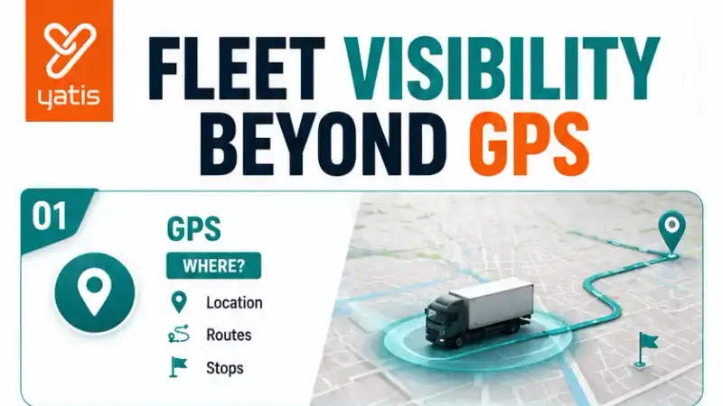
GPS. Where is the vehicle?
Layer 2 — Vehicle
Telematics and diagnostics. What is the vehicle doing?
Layer 3 — Human
Driver and video. What is the driver doing and what happened around the vehicle?
Layer 4 — Environment
IoT sensors. What is happening around the vehicle, asset or cargo?
Layer 5 — Intelligence
Analytics and AI. What does all of this information mean?
Together, these layers provide a much richer operational picture than GPS alone.
GPS: The Location Layer
GPS remains the foundation of fleet visibility. It provides the geographical context needed to understand vehicle position, movement, routes, stops, distance, arrival and departure, and geofence activity.
Without location, many other fleet events lose context. "Harsh braking detected" is useful. But harsh braking detected at a specific location, on a specific route, at a specific time is much more actionable. GPS therefore remains the spatial foundation of fleet intelligence.
Telematics: What Is the Vehicle Doing?
Location doesn't tell you everything about the vehicle itself. Telematics can add information such as speed, engine data, diagnostics, ignition, fuel, mileage, operating hours and vehicle health indicators.
Now consider the same stopped vehicle. GPS reports it stopped at 14:32. Telematics reports the engine is running. Fuel data shows consumption increasing. Suddenly the event has more context.
The combination of location and vehicle data is far more useful than either signal in isolation.
Video Telematics: What Actually Happened?
This is the next major layer. Imagine an event at 14:32. GPS says the vehicle stopped. Telematics reports a harsh braking event. Video shows the vehicle encountered a pedestrian crossing the road. Now the fleet manager has a much more complete picture.
This is why video telematics can transform an event from a data point into evidence. Modern fleet platforms increasingly synchronize GPS, vehicle events and video so that operators can investigate incidents using multiple sources of context rather than reviewing each system independently.
The principle: GPS tells you where. Video helps explain what happened there.
IoT: Seeing Beyond the Vehicle
Fleet visibility doesn't always end with the vehicle. IoT sensors can monitor additional conditions depending on the operation, including temperature, cargo conditions, door status, asset movement, equipment state and environmental conditions.
Consider a refrigerated truck. GPS says the truck arrived at the warehouse. Temperature data says cargo temperature exceeded the configured range. Now the fleet team knows that an apparently successful delivery may require investigation. The same principle applies to other connected assets.
GPS provides location. IoT provides condition.
Analytics: Turning Multiple Signals Into Meaning
Having five different data streams doesn't automatically create visibility. You need to make sense of them.
Suppose GPS shows the vehicle delayed, telematics shows the engine running, video shows a loading area, IoT reports cargo temperature normal, and trip data shows dwell time above normal. Analytics can bring those signals together and identify extended loading-site dwell time.
That's much more useful than five disconnected notifications. This is where the concept of fleet visibility starts moving toward fleet intelligence.
One Event Can Have Multiple Data Sources
Consider a harsh-braking event. GPS supplies the location. Telematics supplies speed and the braking event itself. Video supplies road context. Driver data supplies the driver's history. Analytics supplies event severity and whether the pattern is recurring.
Now the fleet manager can ask whether this is an isolated event or part of a recurring risk pattern. That's a fundamentally better question than simply asking whether harsh braking occurred.
The Problem With Fragmented Fleet Systems
Many fleets gradually build technology one requirement at a time: a GPS platform, then a dashcam platform, then a fuel system, then maintenance software, then an IoT platform.
Each system may work perfectly on its own. The problem appears when the fleet manager has to reconstruct an incident manually across System A for vehicle location, System B for video, System C for fuel, System D for maintenance and System E for driver information.
The result can be more logins, more exports, more manual comparison and more disconnected data. A unified fleet visibility approach tries to reduce that fragmentation by bringing relevant data into a common operational view. Current fleet platforms increasingly position GPS, video, fuel, maintenance and IoT as integrated layers rather than isolated tools.
What Does a Fleet Visibility Platform Actually Do?
A fleet visibility platform brings data from connected vehicles, GPS trackers, telematics, video systems and IoT devices into a shared environment. It allows fleet teams to monitor operations, investigate events, compare performance and make decisions using a more complete view of fleet activity.
The objective isn't one screen containing everything — that's often a bad dashboard. The objective is one connected source of operational context. Different teams can then use the same underlying data.
Fleet Visibility for Different Teams
A unified visibility system can answer different questions for different teams.
Operations
Where are vehicles? Which trips are delayed? Which vehicles are available?
Safety
Which incidents occurred? What happened during the event? Which behaviours are recurring?
Maintenance
Which vehicles need attention? What diagnostic signals are appearing?
Management
How is the fleet performing? Where are costs or risks increasing?
Customer Service
Where is the delivery? What is the latest operational status?
The underlying data can be shared while the use case changes by department.
Fleet Visibility Is About Context, Not Just More Data
This distinction is critical. Adding another sensor doesn't automatically improve visibility.
Suppose a fleet generates GPS, fuel, video, diagnostics and IoT data, but every system remains disconnected. You have more data. Not necessarily more visibility.
Visibility improves when those signals can be connected, contextualized and understood together. That is the difference between a technology stack and an operational platform.
What Does Unified Visibility Look Like?
Imagine a single incident on Vehicle 204. Location: highway NH-16. Speed: 68 km/h. Event: harsh braking. Video: road obstruction detected. Driver: four previous harsh-braking events. Vehicle: no active diagnostic fault. Recommended action: safety review.
Now one incident contains where, what, context, history and action. That's much closer to genuine fleet visibility.
Fleet Visibility vs GPS Tracking
These terms should not be treated as interchangeable.
| GPS Tracking | Fleet Visibility |
|---|---|
| Primarily location-focused | Multi-source operational view |
| Vehicle position | Vehicle, driver, asset and environment |
| Trip history | Operational context |
| Route information | Cross-system event context |
| Basic alerts | Connected event intelligence |
| Answers where? | Answers where, what and why? |
GPS remains part of fleet visibility. It simply isn't the entire definition.
Fleet Visibility vs Fleet Analytics
Analytics and visibility are related but different. Visibility helps you see what's happening. Analytics helps you understand patterns and performance.
For example, visibility reports that Vehicle 45 is stopped. Analytics reports that Vehicle 45 has exceeded its normal dwell time by 32%. Together, visibility and analytics create a stronger operational picture.
Fleet Visibility and AI
AI can add another layer. Once multiple sources are connected, AI can potentially detect anomalies, prioritize incidents, recognize patterns, analyse video, identify risk and surface important events.
But AI should not be confused with visibility itself. Visibility connects and presents the operational picture. AI uses intelligence to identify what matters within that picture.
Fleet Visibility and Predictive Management
The same distinction applies to prediction. Fleet visibility asks what is happening across the operation. Predictive fleet management asks what may happen next. A digital twin asks what could happen if we change something.
The technologies build on one another rather than replacing one another.
The Modern Fleet Visibility Stack
What Should Businesses Look for in a Fleet Visibility Platform?
Don't judge a platform by the number of features listed on its website. Ask better questions.
1. Can different data sources work together?
GPS, video, vehicle data, IoT and other relevant systems.
2. Can an event be investigated in context?
Can you move from event to location to video to vehicle to driver to history?
3. Is the data accessible to different teams?
Operations, safety, maintenance and management shouldn't have completely separate versions of reality.
4. Can the platform integrate with existing systems?
APIs and integrations can be important when businesses already have operational software.
5. Can users configure what matters to them?
A control room and a fleet executive don't need the same dashboard.
6. Does the platform reduce manual reconciliation?
This is a major practical test. If people still spend hours exporting data from five systems to understand one incident, visibility remains fragmented.
The Goal Isn't More Technology
This may be the most important conclusion for fleet managers. A connected fleet can have ten systems and still have poor visibility. Another fleet can have fewer systems but a much better operational picture because its data is connected and actionable.
So the goal isn't to add another technology. The goal is to connect the information required to make better decisions. That's what makes a fleet visibility platform valuable.
Conclusion
GPS tracking made vehicle location visible. Telematics added vehicle context. Video added visual evidence. IoT added environmental and asset information. Analytics turned data into measurable performance. AI added intelligent interpretation. Predictive models added anticipation. Digital twins introduced scenario modelling.
The next step is connecting these capabilities into a coherent operational view. That is what fleet visibility beyond GPS is really about. Not another dashboard. Not another tracker. Not simply more data.
It is the ability to move from "where is my vehicle?" to "what is happening across my operation, why does it matter, and what should we do next?" That is the difference between tracking a fleet and understanding a fleet.
Frequently Asked Questions
Ready to get started?
Contact Yatis Telematics to see how GPS, video, telematics and IoT data can come together in a single operational view.
Contact Us →